


20210524

fredodlageo
Gebruiker

Lengte
17,8 km

Max. hoogte
377 m

Positief hoogteverschil
435 m
Km-Effort
24 km

Min. hoogte
193 m

Negatief hoogteverschil
435 m
Boucle
Ja
Datum van aanmaak :
2021-05-24 12:28:48.0
Laatste wijziging :
2021-05-24 13:56:11.693
1h26
Moeilijkheid : Medium

Gratisgps-wandelapplicatie
 SityTrail
IGN / Geografische instituten
SityTrail Plus
De wereld gaat voor u open
Over ons
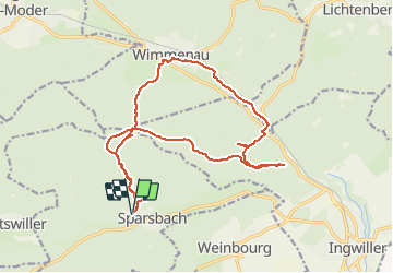
Tocht Mountainbike van 17,8 km beschikbaar op Grand Est, Bas-Rhin, Sparsbach. Deze tocht wordt voorgesteld door fredodlageo.
Beschrijving
Sortie vtt
Plaatsbepaling
Land:
France
Regio :
Grand Est
Departement/Provincie :
Bas-Rhin
Gemeente :
Sparsbach
Locatie:
Unknown
Vertrek:(Dec)
Vertrek:(UTM)
383339 ; 5415194 (32U) N.
Opmerkingen