


13092086-SISTERON NICE 6 APRES TEMPETE

nicolas54230
Gebruiker

Lengte
33 km

Max. hoogte
870 m

Positief hoogteverschil
1413 m
Km-Effort
53 km

Min. hoogte
100 m

Negatief hoogteverschil
1645 m
Boucle
Neen
Datum van aanmaak :
2021-05-24 16:38:27.183
Laatste wijziging :
2021-06-07 08:50:19.698
3h39
Moeilijkheid : Zeer moeilijk

Gratisgps-wandelapplicatie
 SityTrail
IGN / Geografische instituten
SityTrail Plus
De wereld gaat voor u open
Over ons
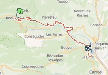
Tocht Mountainbike van 33 km beschikbaar op Provence-Alpes-Côte d'Azur, Alpes-Maritimes, Roquestéron. Deze tocht wordt voorgesteld door nicolas54230.
Plaatsbepaling
Land:
France
Regio :
Provence-Alpes-Côte d'Azur
Departement/Provincie :
Alpes-Maritimes
Gemeente :
Roquestéron
Locatie:
Unknown
Vertrek:(Dec)
Vertrek:(UTM)
339781 ; 4859832 (32T) N.
Opmerkingen