


Grossweberbach - Les confins des cantons de l'Est

AnneCecile
Gebruiker

Lengte
9,6 km

Max. hoogte
570 m

Positief hoogteverschil
198 m
Km-Effort
12,3 km

Min. hoogte
421 m

Negatief hoogteverschil
198 m
Boucle
Ja
Datum van aanmaak :
2021-05-29 09:00:51.133
Laatste wijziging :
2021-06-27 07:00:02.451
2h35
Moeilijkheid : Medium

Gratisgps-wandelapplicatie
 SityTrail
IGN / Geografische instituten
SityTrail Plus
De wereld gaat voor u open
Over ons
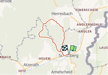
Tocht Stappen van 9,6 km beschikbaar op Wallonië, Luik, Sankt Vith. Deze tocht wordt voorgesteld door AnneCecile.
Beschrijving
Départ : Eglise de Schönberg, 4782, Saint-vith
Plaatsbepaling
Land:
Belgium
Regio :
Wallonië
Departement/Provincie :
Luik
Gemeente :
Sankt Vith
Locatie:
Unknown
Vertrek:(Dec)
Vertrek:(UTM)
305188 ; 5574369 (32U) N.
Opmerkingen