


LONLAY 22K

UDGI54
Gebruiker
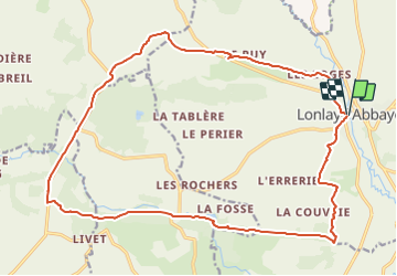

Lengte
22 km

Max. hoogte
267 m

Positief hoogteverschil
404 m
Km-Effort
27 km

Min. hoogte
140 m

Negatief hoogteverschil
406 m
Boucle
Ja
Datum van aanmaak :
2021-05-30 19:34:01.86
Laatste wijziging :
2021-05-30 19:34:38.572
6h07
Moeilijkheid : Zeer moeilijk

Gratisgps-wandelapplicatie
 SityTrail
IGN / Geografische instituten
SityTrail Plus
De wereld gaat voor u open
Over ons
Tocht Stappen van 22 km beschikbaar op Normandië, Orne, Lonlay-l'Abbaye. Deze tocht wordt voorgesteld door UDGI54.
Plaatsbepaling
Land:
France
Regio :
Normandië
Departement/Provincie :
Orne
Gemeente :
Lonlay-l'Abbaye
Locatie:
Unknown
Vertrek:(Dec)
Vertrek:(UTM)
668662 ; 5390584 (30U) N.
Opmerkingen