


SityTrail - Boucle Heinstert-Louftémont 27 KM

ochelen
Gebruiker
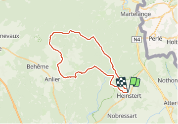

Lengte
27 km

Max. hoogte
515 m

Positief hoogteverschil
507 m
Km-Effort
33 km

Min. hoogte
409 m

Negatief hoogteverschil
507 m
Boucle
Ja
Datum van aanmaak :
2021-06-01 19:55:44.315
Laatste wijziging :
2021-06-01 19:55:44.315

Gratisgps-wandelapplicatie
 SityTrail
IGN / Geografische instituten
SityTrail Plus
De wereld gaat voor u open
Over ons
Tocht van 27 km beschikbaar op Wallonië, Luxemburg, Attert. Deze tocht wordt voorgesteld door ochelen.
Beschrijving
Depart: Ferme D'a Yaaz
Plaatsbepaling
Land:
Belgium
Regio :
Wallonië
Departement/Provincie :
Luxemburg
Gemeente :
Attert
Locatie:
Unknown
Vertrek:(Dec)
Vertrek:(UTM)
696405 ; 5515566 (31U) N.
Opmerkingen