


fontaine ledun

dedejojo
Gebruiker
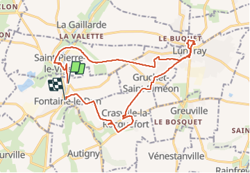

Lengte
18,1 km

Max. hoogte
105 m

Positief hoogteverschil
164 m
Km-Effort
20 km

Min. hoogte
34 m

Negatief hoogteverschil
179 m
Boucle
Neen
Datum van aanmaak :
2021-06-06 08:09:44.024
Laatste wijziging :
2021-06-06 14:22:01.144
6h10
Moeilijkheid : Heel gemakkelijk

Gratisgps-wandelapplicatie
 SityTrail
IGN / Geografische instituten
SityTrail Plus
De wereld gaat voor u open
Over ons
Tocht Stappen van 18,1 km beschikbaar op Normandië, Seine-Maritime, Fontaine-le-Dun. Deze tocht wordt voorgesteld door dedejojo.
Plaatsbepaling
Land:
France
Regio :
Normandië
Departement/Provincie :
Seine-Maritime
Gemeente :
Fontaine-le-Dun
Locatie:
Unknown
Vertrek:(Dec)
Vertrek:(UTM)
345460 ; 5520578 (31U) N.
Opmerkingen