


Bois -de-Villers SNS 10- 6- 2021

sarriette
Gebruiker
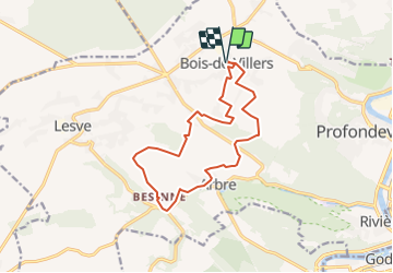

Lengte
13 km

Max. hoogte
265 m

Positief hoogteverschil
269 m
Km-Effort
16,6 km

Min. hoogte
147 m

Negatief hoogteverschil
269 m
Boucle
Ja
Datum van aanmaak :
2021-06-09 20:11:16.207
Laatste wijziging :
2021-06-09 20:11:16.207
--
Moeilijkheid : Onbekend

Gratisgps-wandelapplicatie
 SityTrail
IGN / Geografische instituten
SityTrail Plus
De wereld gaat voor u open
Over ons
Tocht Trail van 13 km beschikbaar op Wallonië, Namen, Profondeville. Deze tocht wordt voorgesteld door sarriette.
Plaatsbepaling
Land:
Belgium
Regio :
Wallonië
Departement/Provincie :
Namen
Gemeente :
Profondeville
Locatie:
Bois-de-Villers
Vertrek:(Dec)
Vertrek:(UTM)
629615 ; 5583583 (31U) N.
Opmerkingen