


Le mont Viroulet depuis St Dalmas

alainfauvet
Gebruiker
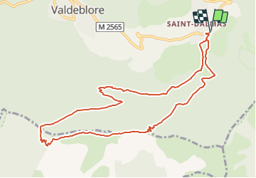

Lengte
11,7 km

Max. hoogte
1860 m

Positief hoogteverschil
615 m
Km-Effort
19,9 km

Min. hoogte
1283 m

Negatief hoogteverschil
615 m
Boucle
Ja
Datum van aanmaak :
2021-06-15 11:34:29.196
Laatste wijziging :
2021-06-15 11:36:42.523
4h31
Moeilijkheid : Gemakkelijk

Gratisgps-wandelapplicatie
 SityTrail
IGN / Geografische instituten
SityTrail Plus
De wereld gaat voor u open
Over ons
Tocht Te voet van 11,7 km beschikbaar op Provence-Alpes-Côte d'Azur, Alpes-Maritimes, Valdeblore. Deze tocht wordt voorgesteld door alainfauvet.
Beschrijving
Parcours essentiellement en Ubac
Plaatsbepaling
Land:
France
Regio :
Provence-Alpes-Côte d'Azur
Departement/Provincie :
Alpes-Maritimes
Gemeente :
Valdeblore
Locatie:
Unknown
Vertrek:(Dec)
Vertrek:(UTM)
356179 ; 4880864 (32T) N.
Opmerkingen