


2021-06-19_13h44m46_redu-parcours-vtt-de-la-haute-lesse (1)

thomas1986
Gebruiker
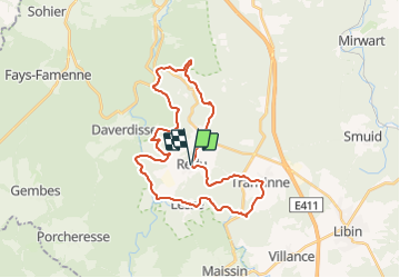

Lengte
29 km

Max. hoogte
443 m

Positief hoogteverschil
729 m
Km-Effort
39 km

Min. hoogte
215 m

Negatief hoogteverschil
739 m
Boucle
Ja
Datum van aanmaak :
2021-06-19 11:44:47.046
Laatste wijziging :
2021-07-25 19:06:44.993
2h42
Moeilijkheid : Medium

Gratisgps-wandelapplicatie
 SityTrail
IGN / Geografische instituten
SityTrail Plus
De wereld gaat voor u open
Over ons
Tocht Mountainbike van 29 km beschikbaar op Wallonië, Luxemburg, Libin. Deze tocht wordt voorgesteld door thomas1986.
Plaatsbepaling
Land:
Belgium
Regio :
Wallonië
Departement/Provincie :
Luxemburg
Gemeente :
Libin
Locatie:
Unknown
Vertrek:(Dec)
Vertrek:(UTM)
654758 ; 5541672 (31U) N.
Opmerkingen