


6666666666 14:44:14

UDGI54
Gebruiker
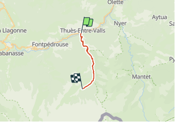

Lengte
11,9 km

Max. hoogte
1838 m

Positief hoogteverschil
1253 m
Km-Effort
25 km

Min. hoogte
844 m

Negatief hoogteverschil
270 m
Boucle
Neen
Datum van aanmaak :
2021-06-20 19:21:52.133
Laatste wijziging :
2021-06-20 19:40:26.835

Gratisgps-wandelapplicatie
 SityTrail
IGN / Geografische instituten
SityTrail Plus
De wereld gaat voor u open
Over ons
Tocht van 11,9 km beschikbaar op Occitanië, Pyrénées-Orientales, Thuès-Entre-Valls. Deze tocht wordt voorgesteld door UDGI54.
Plaatsbepaling
Land:
France
Regio :
Occitanië
Departement/Provincie :
Pyrénées-Orientales
Gemeente :
Thuès-Entre-Valls
Locatie:
Unknown
Vertrek:(Dec)
Vertrek:(UTM)
436066 ; 4708096 (31T) N.
Opmerkingen