


7777777779 15:21:17

UDGI54
Gebruiker
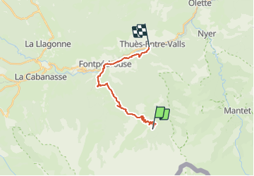

Lengte
18,5 km

Max. hoogte
2387 m

Positief hoogteverschil
805 m
Km-Effort
33 km

Min. hoogte
836 m

Negatief hoogteverschil
1799 m
Boucle
Neen
Datum van aanmaak :
2021-06-20 19:40:58.122
Laatste wijziging :
2021-06-20 19:49:33.046

Gratisgps-wandelapplicatie
 SityTrail
IGN / Geografische instituten
SityTrail Plus
De wereld gaat voor u open
Over ons
Tocht van 18,5 km beschikbaar op Occitanië, Pyrénées-Orientales, Fontpédrouse. Deze tocht wordt voorgesteld door UDGI54.
Plaatsbepaling
Land:
France
Regio :
Occitanië
Departement/Provincie :
Pyrénées-Orientales
Gemeente :
Fontpédrouse
Locatie:
Unknown
Vertrek:(Dec)
Vertrek:(UTM)
436193 ; 4701627 (31T) N.
Opmerkingen