


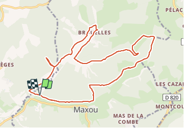
Environ de Maxou

fxhedon
Gebruiker

Lengte
12,4 km

Max. hoogte
337 m

Positief hoogteverschil
232 m
Km-Effort
15,4 km

Min. hoogte
184 m

Negatief hoogteverschil
227 m
Boucle
Ja
Datum van aanmaak :
2021-06-19 07:36:32.0
Laatste wijziging :
2021-06-23 08:17:45.623
3h04
Moeilijkheid : Heel gemakkelijk

Gratisgps-wandelapplicatie
 SityTrail
IGN / Geografische instituten
SityTrail Plus
De wereld gaat voor u open
Over ons
Tocht Stappen van 12,4 km beschikbaar op Occitanië, Lot, Maxou. Deze tocht wordt voorgesteld door fxhedon.
Beschrijving
Très belle promenade sur vallons et plateau
Plaatsbepaling
Land:
France
Regio :
Occitanië
Departement/Provincie :
Lot
Gemeente :
Maxou
Locatie:
Unknown
Vertrek:(Dec)
Vertrek:(UTM)
375065 ; 4932989 (31T) N.
Opmerkingen