


raccourcis st Barnabé

fab4u
Gebruiker
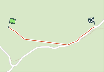

Lengte
290 m

Max. hoogte
947 m

Positief hoogteverschil
3 m
Km-Effort
323 m

Min. hoogte
941 m

Negatief hoogteverschil
1 m
Boucle
Neen
Datum van aanmaak :
2021-06-30 19:52:30.597
Laatste wijziging :
2021-06-30 19:57:48.743
5m
Moeilijkheid : Gemakkelijk

Gratisgps-wandelapplicatie
 SityTrail
IGN / Geografische instituten
SityTrail Plus
De wereld gaat voor u open
Over ons
Tocht Stappen van 290 m beschikbaar op Provence-Alpes-Côte d'Azur, Alpes-Maritimes, Courmes. Deze tocht wordt voorgesteld door fab4u.
Plaatsbepaling
Land:
France
Regio :
Provence-Alpes-Côte d'Azur
Departement/Provincie :
Alpes-Maritimes
Gemeente :
Courmes
Locatie:
Unknown
Vertrek:(Dec)
Vertrek:(UTM)
341378 ; 4846762 (32T) N.
Opmerkingen