


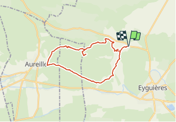
Les Opies 16,5km

thonyc
Gebruiker GUIDE

Lengte
15,1 km

Max. hoogte
479 m

Positief hoogteverschil
424 m
Km-Effort
21 km

Min. hoogte
124 m

Negatief hoogteverschil
423 m
Boucle
Ja
Datum van aanmaak :
2021-07-04 16:19:03.469
Laatste wijziging :
2021-07-17 18:17:48.576
4h49
Moeilijkheid : Zeer moeilijk

Gratisgps-wandelapplicatie
 SityTrail
IGN / Geografische instituten
SityTrail Plus
De wereld gaat voor u open
Over ons
Tocht Stappen van 15,1 km beschikbaar op Provence-Alpes-Côte d'Azur, Bouches-du-Rhône, Eyguières. Deze tocht wordt voorgesteld door thonyc.
Plaatsbepaling
Land:
France
Regio :
Provence-Alpes-Côte d'Azur
Departement/Provincie :
Bouches-du-Rhône
Gemeente :
Eyguières
Locatie:
Unknown
Vertrek:(Dec)
Vertrek:(UTM)
662141 ; 4842317 (31T) N.
Opmerkingen