


Route Corunum reconnaissance 1

fxhedon
Gebruiker

Lengte
5,7 km

Max. hoogte
1552 m

Positief hoogteverschil
103 m
Km-Effort
8,8 km

Min. hoogte
1019 m

Negatief hoogteverschil
628 m
Boucle
Neen
Datum van aanmaak :
2021-07-05 09:16:48.0
Laatste wijziging :
2021-07-05 12:21:19.223
2h57
Moeilijkheid : Medium

Gratisgps-wandelapplicatie
 SityTrail
IGN / Geografische instituten
SityTrail Plus
De wereld gaat voor u open
Over ons
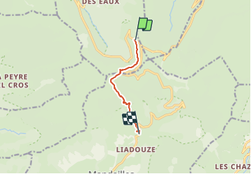
Tocht Stappen van 5,7 km beschikbaar op Auvergne-Rhône-Alpes, Cantal, Le Falgoux. Deze tocht wordt voorgesteld door fxhedon.
Beschrijving
Reconnaissance corunum
Plaatsbepaling
Land:
France
Regio :
Auvergne-Rhône-Alpes
Departement/Provincie :
Cantal
Gemeente :
Le Falgoux
Locatie:
Unknown
Vertrek:(Dec)
Vertrek:(UTM)
473972 ; 4995876 (31T) N.
Opmerkingen