


hr 92 escala a estartit

babouille
Gebruiker
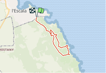

Lengte
13,5 km

Max. hoogte
167 m

Positief hoogteverschil
323 m
Km-Effort
17,8 km

Min. hoogte
8 m

Negatief hoogteverschil
323 m
Boucle
Ja
Datum van aanmaak :
2021-07-08 06:32:27.609
Laatste wijziging :
2021-07-08 08:49:21.46
2h15
Moeilijkheid : Moeilijk

Gratisgps-wandelapplicatie
 SityTrail
IGN / Geografische instituten
SityTrail Plus
De wereld gaat voor u open
Over ons
Tocht Lopen van 13,5 km beschikbaar op Catalonië, Gerona, l'Escala. Deze tocht wordt voorgesteld door babouille.
Plaatsbepaling
Land:
Spain
Regio :
Catalonië
Departement/Provincie :
Gerona
Gemeente :
l'Escala
Locatie:
Unknown
Vertrek:(Dec)
Vertrek:(UTM)
513171 ; 4661759 (31T) N.
Opmerkingen