


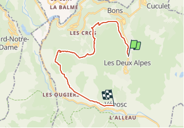
venosc par le sapey

kikkko
Gebruiker

Lengte
13 km

Max. hoogte
1716 m

Positief hoogteverschil
338 m
Km-Effort
19,6 km

Min. hoogte
983 m

Negatief hoogteverschil
971 m
Boucle
Neen
Datum van aanmaak :
2021-07-13 09:25:05.646
Laatste wijziging :
2021-07-13 15:01:47.99
3h07
Moeilijkheid : Medium

Gratisgps-wandelapplicatie
 SityTrail
IGN / Geografische instituten
SityTrail Plus
De wereld gaat voor u open
Over ons
Tocht Stappen van 13 km beschikbaar op Auvergne-Rhône-Alpes, Isère, Les Deux Alpes. Deze tocht wordt voorgesteld door kikkko.
Beschrijving
Tour du pied moutet, quelques passages aériens
Plaatsbepaling
Land:
France
Regio :
Auvergne-Rhône-Alpes
Departement/Provincie :
Isère
Gemeente :
Les Deux Alpes
Locatie:
Unknown
Vertrek:(Dec)
Vertrek:(UTM)
273426 ; 4988416 (32T) N.
Opmerkingen