


bg

dedejojo
Gebruiker
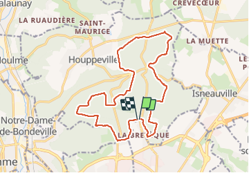

Lengte
17,9 km

Max. hoogte
185 m

Positief hoogteverschil
362 m
Km-Effort
23 km

Min. hoogte
82 m

Negatief hoogteverschil
355 m
Boucle
Ja
Datum van aanmaak :
2021-07-14 09:00:52.337
Laatste wijziging :
2021-07-14 14:49:51.977
5h46
Moeilijkheid : Heel gemakkelijk

Gratisgps-wandelapplicatie
 SityTrail
IGN / Geografische instituten
SityTrail Plus
De wereld gaat voor u open
Over ons
Tocht Stappen van 17,9 km beschikbaar op Normandië, Seine-Maritime, Houppeville. Deze tocht wordt voorgesteld door dedejojo.
Plaatsbepaling
Land:
France
Regio :
Normandië
Departement/Provincie :
Seine-Maritime
Gemeente :
Houppeville
Locatie:
Unknown
Vertrek:(Dec)
Vertrek:(UTM)
362705 ; 5483696 (31U) N.
Opmerkingen