


la roche qui chome

nolsim
Gebruiker
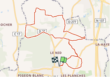

Lengte
13,1 km

Max. hoogte
106 m

Positief hoogteverschil
147 m
Km-Effort
15,1 km

Min. hoogte
28 m

Negatief hoogteverschil
147 m
Boucle
Ja
Datum van aanmaak :
2021-07-16 11:52:32.649
Laatste wijziging :
2021-07-16 15:08:34.595
3h01
Moeilijkheid : Gemakkelijk

Gratisgps-wandelapplicatie
 SityTrail
IGN / Geografische instituten
SityTrail Plus
De wereld gaat voor u open
Over ons
Tocht Stappen van 13,1 km beschikbaar op Bretagne, Ille-et-Vilaine, Laillé. Deze tocht wordt voorgesteld door nolsim.
Plaatsbepaling
Land:
France
Regio :
Bretagne
Departement/Provincie :
Ille-et-Vilaine
Gemeente :
Laillé
Locatie:
Unknown
Vertrek:(Dec)
Vertrek:(UTM)
595791 ; 5315145 (30T) N.
Opmerkingen