


francette j7 St généroux parthenay

werth
Gebruiker
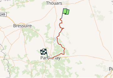

Lengte
56 km

Max. hoogte
180 m

Positief hoogteverschil
621 m
Km-Effort
64 km

Min. hoogte
62 m

Negatief hoogteverschil
571 m
Boucle
Neen
Datum van aanmaak :
2021-08-07 07:03:54.967
Laatste wijziging :
2021-08-09 19:06:46.655
8h49
Moeilijkheid : Moeilijk

Gratisgps-wandelapplicatie
 SityTrail
IGN / Geografische instituten
SityTrail Plus
De wereld gaat voor u open
Over ons
Tocht Fietstoerisme van 56 km beschikbaar op Nieuw-Aquitanië, Deux-Sèvres, Saint-Généroux. Deze tocht wordt voorgesteld door werth.
Beschrijving
vent, montées et descentes toute la journée. mais le parcours est très joli
Plaatsbepaling
Land:
France
Regio :
Nieuw-Aquitanië
Departement/Provincie :
Deux-Sèvres
Gemeente :
Saint-Généroux
Locatie:
Unknown
Vertrek:(Dec)
Vertrek:(UTM)
717276 ; 5196417 (30T) N.
Opmerkingen