


2021 08 BAGNOLS T3

michel1025
Gebruiker
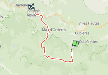

Lengte
20 km

Max. hoogte
1699 m

Positief hoogteverschil
385 m
Km-Effort
27 km

Min. hoogte
910 m

Negatief hoogteverschil
949 m
Boucle
Neen
Datum van aanmaak :
2021-08-11 07:40:48.0
Laatste wijziging :
2021-08-11 15:00:52.73
6h19
Moeilijkheid : Zeer moeilijk

Gratisgps-wandelapplicatie
 SityTrail
IGN / Geografische instituten
SityTrail Plus
De wereld gaat voor u open
Over ons
Tocht Stappen van 20 km beschikbaar op Occitanië, Lozère, Cubières. Deze tocht wordt voorgesteld door michel1025.
Plaatsbepaling
Land:
France
Regio :
Occitanië
Departement/Provincie :
Lozère
Gemeente :
Cubières
Locatie:
Unknown
Vertrek:(Dec)
Vertrek:(UTM)
559533 ; 4921618 (31T) N.
Opmerkingen