


Chambon sur Cisse

nolsim
Gebruiker

Lengte
12,4 km

Max. hoogte
132 m

Positief hoogteverschil
216 m
Km-Effort
15,3 km

Min. hoogte
73 m

Negatief hoogteverschil
213 m
Boucle
Ja
Datum van aanmaak :
2021-08-19 08:30:35.142
Laatste wijziging :
2021-08-19 12:59:46.838
3h21
Moeilijkheid : Gemakkelijk

Gratisgps-wandelapplicatie
 SityTrail
IGN / Geografische instituten
SityTrail Plus
De wereld gaat voor u open
Over ons
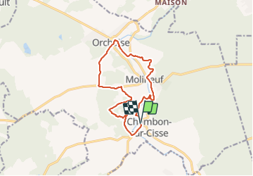
Tocht Stappen van 12,4 km beschikbaar op Centre-Val de Loire, Loir-et-Cher, Valencisse. Deze tocht wordt voorgesteld door nolsim.
Foto's


Plaatsbepaling
Land:
France
Regio :
Centre-Val de Loire
Departement/Provincie :
Loir-et-Cher
Gemeente :
Valencisse
Locatie:
Unknown
Vertrek:(Dec)
Vertrek:(UTM)
365574 ; 5269296 (31T) N.
Opmerkingen