


SA2021 Dim

PhilippeC54
Gebruiker

Lengte
27 km

Max. hoogte
311 m

Positief hoogteverschil
389 m
Km-Effort
32 km

Min. hoogte
190 m

Negatief hoogteverschil
389 m
Boucle
Ja
Datum van aanmaak :
2021-08-22 12:07:25.972
Laatste wijziging :
2021-08-29 16:21:22.4
2h08
Moeilijkheid : Gemakkelijk

Gratisgps-wandelapplicatie
 SityTrail
IGN / Geografische instituten
SityTrail Plus
De wereld gaat voor u open
Over ons
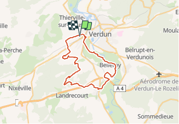
Tocht Mountainbike van 27 km beschikbaar op Grand Est, Meuse, Verdun. Deze tocht wordt voorgesteld door PhilippeC54.
Plaatsbepaling
Land:
France
Regio :
Grand Est
Departement/Provincie :
Meuse
Gemeente :
Verdun
Locatie:
Unknown
Vertrek:(Dec)
Vertrek:(UTM)
671989 ; 5447526 (31U) N.
Opmerkingen