


68.943 Faulx les Tombes - Hautbois

ADL339
Gebruiker
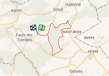

Lengte
10,9 km

Max. hoogte
288 m

Positief hoogteverschil
186 m
Km-Effort
13,4 km

Min. hoogte
183 m

Negatief hoogteverschil
187 m
Boucle
Ja
Datum van aanmaak :
2021-08-28 08:49:04.0
Laatste wijziging :
2021-08-28 08:48:50.124
3h03
Moeilijkheid : Gemakkelijk

Gratisgps-wandelapplicatie
 SityTrail
IGN / Geografische instituten
SityTrail Plus
De wereld gaat voor u open
Over ons
Tocht Stappen van 10,9 km beschikbaar op Wallonië, Namen, Gesves. Deze tocht wordt voorgesteld door ADL339.
Plaatsbepaling
Land:
Belgium
Regio :
Wallonië
Departement/Provincie :
Namen
Gemeente :
Gesves
Locatie:
Unknown
Vertrek:(Dec)
Vertrek:(UTM)
644482 ; 5588330 (31U) N.
Opmerkingen