


Bruno 05/09/2021

maginot
Gebruiker
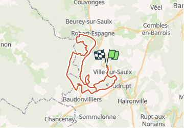

Lengte
34 km

Max. hoogte
246 m

Positief hoogteverschil
460 m
Km-Effort
40 km

Min. hoogte
167 m

Negatief hoogteverschil
463 m
Boucle
Ja
Datum van aanmaak :
2021-09-05 13:49:52.0
Laatste wijziging :
2021-09-05 21:47:47.996
7h50
Moeilijkheid : Gemakkelijk

Gratisgps-wandelapplicatie
 SityTrail
IGN / Geografische instituten
SityTrail Plus
De wereld gaat voor u open
Over ons
Tocht Mountainbike van 34 km beschikbaar op Grand Est, Meuse, L'Isle-en-Rigault. Deze tocht wordt voorgesteld door maginot.
Plaatsbepaling
Land:
France
Regio :
Grand Est
Departement/Provincie :
Meuse
Gemeente :
L'Isle-en-Rigault
Locatie:
Unknown
Vertrek:(Dec)
Vertrek:(UTM)
650775 ; 5398022 (31U) N.
Opmerkingen