


Sibérie Full sentiers. Sacre dénivelé

thomarche
Gebruiker
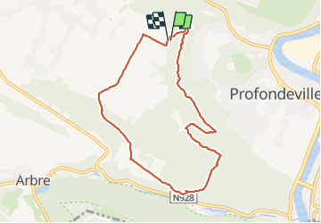

Lengte
8 km

Max. hoogte
267 m

Positief hoogteverschil
235 m
Km-Effort
11,1 km

Min. hoogte
135 m

Negatief hoogteverschil
231 m
Boucle
Ja
Datum van aanmaak :
2021-09-22 13:08:55.0
Laatste wijziging :
2021-09-22 15:41:40.783
2h32
Moeilijkheid : Medium

Gratisgps-wandelapplicatie
 SityTrail
IGN / Geografische instituten
SityTrail Plus
De wereld gaat voor u open
Over ons
Tocht Stappen van 8 km beschikbaar op Wallonië, Namen, Profondeville. Deze tocht wordt voorgesteld door thomarche.
Plaatsbepaling
Land:
Belgium
Regio :
Wallonië
Departement/Provincie :
Namen
Gemeente :
Profondeville
Locatie:
Profondeville
Vertrek:(Dec)
Vertrek:(UTM)
631319 ; 5582824 (31U) N.
Opmerkingen