


Pouillé dans les vignes

Laurent53
Gebruiker
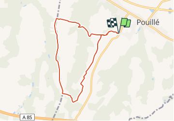

Lengte
7,2 km

Max. hoogte
147 m

Positief hoogteverschil
74 m
Km-Effort
8,2 km

Min. hoogte
90 m

Negatief hoogteverschil
74 m
Boucle
Ja
Datum van aanmaak :
2021-09-29 13:39:18.569
Laatste wijziging :
2021-09-29 13:40:06.215
1h52
Moeilijkheid : Medium

Gratisgps-wandelapplicatie
 SityTrail
IGN / Geografische instituten
SityTrail Plus
De wereld gaat voor u open
Over ons
Tocht Stappen van 7,2 km beschikbaar op Centre-Val de Loire, Loir-et-Cher, Pouillé. Deze tocht wordt voorgesteld door Laurent53.
Plaatsbepaling
Land:
France
Regio :
Centre-Val de Loire
Departement/Provincie :
Loir-et-Cher
Gemeente :
Pouillé
Locatie:
Unknown
Vertrek:(Dec)
Vertrek:(UTM)
369966 ; 5241652 (31T) N.
Opmerkingen