


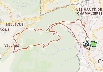
La voie romaine par Villars et les hauts de Chamalières.

jpcccb
Gebruiker

Lengte
6,5 km

Max. hoogte
724 m

Positief hoogteverschil
263 m
Km-Effort
10 km

Min. hoogte
461 m

Negatief hoogteverschil
262 m
Boucle
Ja
Datum van aanmaak :
2021-10-13 14:15:27.852
Laatste wijziging :
2021-10-19 16:49:10.362
2h31
Moeilijkheid : Medium

Gratisgps-wandelapplicatie
 SityTrail
IGN / Geografische instituten
SityTrail Plus
De wereld gaat voor u open
Over ons
Tocht Stappen van 6,5 km beschikbaar op Auvergne-Rhône-Alpes, Puy-de-Dôme, Chamalières. Deze tocht wordt voorgesteld door jpcccb.
Plaatsbepaling
Land:
France
Regio :
Auvergne-Rhône-Alpes
Departement/Provincie :
Puy-de-Dôme
Gemeente :
Chamalières
Locatie:
Unknown
Vertrek:(Dec)
Vertrek:(UTM)
504188 ; 5069094 (31T) N.
Opmerkingen