


2021-10-17_22h12m42_ailhon.gpx (1)

Linerou
Gebruiker

Lengte
6,9 km

Max. hoogte
464 m

Positief hoogteverschil
233 m
Km-Effort
10 km

Min. hoogte
266 m

Negatief hoogteverschil
232 m
Boucle
Ja
Datum van aanmaak :
2021-10-17 20:12:42.719
Laatste wijziging :
2023-12-31 10:54:43.024
2h16
Moeilijkheid : Medium

Gratisgps-wandelapplicatie
 SityTrail
IGN / Geografische instituten
SityTrail Plus
De wereld gaat voor u open
Over ons
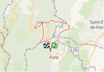
Tocht Stappen van 6,9 km beschikbaar op Auvergne-Rhône-Alpes, Ardèche, Fons. Deze tocht wordt voorgesteld door Linerou.
Beschrijving
Ballade de quelques heures autour d\'Ailhon (église, arboretum), dans les pins sur des sentiers faciles et agréables. Bien pour l\'après-midi, par exemple.
Plaatsbepaling
Land:
France
Regio :
Auvergne-Rhône-Alpes
Departement/Provincie :
Ardèche
Gemeente :
Fons
Locatie:
Unknown
Vertrek:(Dec)
Vertrek:(UTM)
606897 ; 4937767 (31T) N.
Opmerkingen