


St. Aubin le Guichard

werth
Gebruiker

Lengte
12,1 km

Max. hoogte
165 m

Positief hoogteverschil
120 m
Km-Effort
13,7 km

Min. hoogte
114 m

Negatief hoogteverschil
121 m
Boucle
Ja
Datum van aanmaak :
2021-10-19 07:01:44.173
Laatste wijziging :
2021-10-19 11:11:27.408
3h35
Moeilijkheid : Medium

Gratisgps-wandelapplicatie
 SityTrail
IGN / Geografische instituten
SityTrail Plus
De wereld gaat voor u open
Over ons
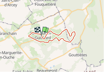
Tocht Stappen van 12,1 km beschikbaar op Normandië, Eure, Mesnil-en-Ouche. Deze tocht wordt voorgesteld door werth.
Plaatsbepaling
Land:
France
Regio :
Normandië
Departement/Provincie :
Eure
Gemeente :
Mesnil-en-Ouche
Locatie:
Unknown
Vertrek:(Dec)
Vertrek:(UTM)
331937 ; 5434293 (31U) N.
Opmerkingen