


Sam 23 oct

Titinechris
Gebruiker
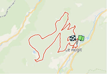

Lengte
12,7 km

Max. hoogte
1180 m

Positief hoogteverschil
567 m
Km-Effort
20 km

Min. hoogte
799 m

Negatief hoogteverschil
567 m
Boucle
Ja
Datum van aanmaak :
2021-10-23 07:27:53.877
Laatste wijziging :
2021-10-23 09:30:57.455
2h02
Moeilijkheid : Gemakkelijk

Gratisgps-wandelapplicatie
 SityTrail
IGN / Geografische instituten
SityTrail Plus
De wereld gaat voor u open
Over ons
Tocht Lopen van 12,7 km beschikbaar op Grand Est, Vogezen, La Bresse. Deze tocht wordt voorgesteld door Titinechris.
Plaatsbepaling
Land:
France
Regio :
Grand Est
Departement/Provincie :
Vogezen
Gemeente :
La Bresse
Locatie:
Unknown
Vertrek:(Dec)
Vertrek:(UTM)
347292 ; 5320887 (32U) N.
Opmerkingen