


Jackbox tests YP.

Alfredy
Gebruiker GUIDE
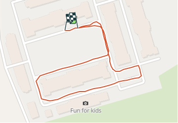

Lengte
576 m

Max. hoogte
198 m

Positief hoogteverschil
3 m
Km-Effort
612 m

Min. hoogte
194 m

Negatief hoogteverschil
2 m
Boucle
Ja
Datum van aanmaak :
2021-10-28 11:22:44.602
Laatste wijziging :
2021-10-28 11:30:59.962
8m
Moeilijkheid : Gemakkelijk

Gratisgps-wandelapplicatie
 SityTrail
IGN / Geografische instituten
SityTrail Plus
De wereld gaat voor u open
Over ons
Tocht Stappen van 576 m beschikbaar op Wallonië, Luik, Blegny. Deze tocht wordt voorgesteld door Alfredy.
Beschrijving
Problèmes si deux tournants proches l'un de l'autre- 28 octobre 2021
Plaatsbepaling
Land:
Belgium
Regio :
Wallonië
Departement/Provincie :
Luik
Gemeente :
Blegny
Locatie:
Unknown
Vertrek:(Dec)
Vertrek:(UTM)
689178 ; 5614718 (31U) N.
Opmerkingen