Les Touches

jeanmarcMasson
Gebruiker GUIDE

Lengte
7,7 km

Max. hoogte
45 m

Positief hoogteverschil
54 m
Km-Effort
8,4 km

Min. hoogte
21 m

Negatief hoogteverschil
53 m
Boucle
Ja
Datum van aanmaak :
2021-10-28 12:18:56.333
Laatste wijziging :
2021-10-28 15:16:02.454
2h13
Moeilijkheid : Medium

Gratisgps-wandelapplicatie
 SityTrail
IGN / Geografische instituten
SityTrail Plus
De wereld gaat voor u open
Over ons
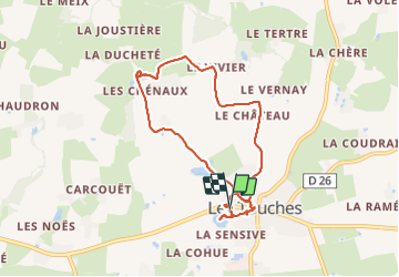
Tocht Stappen van 7,7 km beschikbaar op Pays de la Loire, Loire-Atlantique, Les Touches. Deze tocht wordt voorgesteld door jeanmarcMasson.
Plaatsbepaling
Land:
France
Regio :
Pays de la Loire
Departement/Provincie :
Loire-Atlantique
Gemeente :
Les Touches
Locatie:
Unknown
Vertrek:(Dec)
Vertrek:(UTM)
617971 ; 5255491 (30T) N.
Opmerkingen