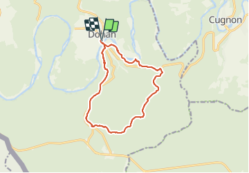
Tocht Stappen Bouillon - Dohan Boucle Sud  - Photo
 thomarche
thomarche

Gebruiker

© OpenStreetMap contributors
Lengte
Lengte
12,2 km
Max. hoogte
Max. hoogte
426 m
Positief hoogteverschil
283 m
Km-Effort
Km-Effort  
15,9 km
Min. hoogte
Min. hoogte
228 m
Negatief hoogteverschil
283 m
Boucle
Boucle
Ja
Datum van aanmaak :
2021-11-03 09:00:49.0
Laatste wijziging :
2021-11-03 12:56:55.365

(0 Bericht)

Stappen
Stappen
3h21
Moeilijkheid : Medium

Scan deze QR-code om de tocht te openen in de SityTrail-applicatie

Gratisgps-wandelapplicatie

Logo SityTrail SityTrail

IGN / Geografische instituten

SityTrail uit de App Store downloaden SityTrail uit Google Play downloaden

Logo SityTrail SityTrail Plus

De wereld gaat voor u open

SityTrail uit de App Store downloaden SityTrail uit Google Play downloaden SityTrail op Huawei AppGallery downloaden

Over ons

Tocht Stappen van 12,2 km beschikbaar op Wallonië, Luxemburg, Bouillon. Deze tocht wordt voorgesteld door thomarche.

Beschrijving

Belle boucle au sud de Dohan principalement e forêt. Points de vue sur la Semois: Roche de Dampiré et un second plus haut. Faites sous une pluie continue donc un peu raccourcie (cabane à pique nique au bord d’une petite route à pile 4km)

Hoogteprofiel

Plaatsbepaling

Land:
Belgium
Regio :
Wallonië
Departement/Provincie :
Luxemburg
Gemeente :
Bouillon
Locatie:
Unknown
Vertrek:(Dec)
Vertrek:(UTM)
654156 ; 5518034 (31U) N.


Sluiten
Mijn abonnementen