


Maubois, Col de L'Evêque, Sommet Uzel, Pic de l'Ours, Pic d'Aurelle retour 3544 ET

verotrail
Gebruiker
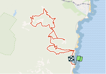

Lengte
14,8 km

Max. hoogte
486 m

Positief hoogteverschil
574 m
Km-Effort
22 km

Min. hoogte
16 m

Negatief hoogteverschil
573 m
Boucle
Ja
Datum van aanmaak :
2021-11-06 09:23:28.601
Laatste wijziging :
2022-01-04 17:05:58.177
5h05
Moeilijkheid : Medium

Gratisgps-wandelapplicatie
 SityTrail
IGN / Geografische instituten
SityTrail Plus
De wereld gaat voor u open
Over ons
Tocht Te voet van 14,8 km beschikbaar op Provence-Alpes-Côte d'Azur, Var, Saint-Raphaël. Deze tocht wordt voorgesteld door verotrail.
Plaatsbepaling
Land:
France
Regio :
Provence-Alpes-Côte d'Azur
Departement/Provincie :
Var
Gemeente :
Saint-Raphaël
Locatie:
Unknown
Vertrek:(Dec)
Vertrek:(UTM)
331832 ; 4813495 (32T) N.
Opmerkingen