


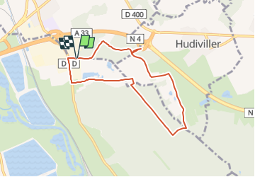
Dombasle _6km _ZI les Sables

ZAMBAUX
Gebruiker

Lengte
6,8 km

Max. hoogte
250 m

Positief hoogteverschil
64 m
Km-Effort
7,7 km

Min. hoogte
222 m

Negatief hoogteverschil
64 m
Boucle
Ja
Datum van aanmaak :
2021-11-06 17:40:58.145
Laatste wijziging :
2023-03-17 08:57:14.401
58m
Moeilijkheid : Gemakkelijk

Gratisgps-wandelapplicatie
 SityTrail
IGN / Geografische instituten
SityTrail Plus
De wereld gaat voor u open
Over ons
Tocht Stappen van 6,8 km beschikbaar op Grand Est, Meurthe-et-Moselle, Dombasle-sur-Meurthe. Deze tocht wordt voorgesteld door ZAMBAUX.
Beschrijving
Rando très facile
Plaatsbepaling
Land:
France
Regio :
Grand Est
Departement/Provincie :
Meurthe-et-Moselle
Gemeente :
Dombasle-sur-Meurthe
Locatie:
Unknown
Vertrek:(Dec)
Vertrek:(UTM)
305758 ; 5386437 (32U) N.
Opmerkingen