


Trail avec Cycl’aventure

domifon
Gebruiker

Lengte
29 km

Max. hoogte
35 m

Positief hoogteverschil
284 m
Km-Effort
33 km

Min. hoogte
-1 m

Negatief hoogteverschil
284 m
Boucle
Ja
Datum van aanmaak :
2021-11-11 08:16:46.0
Laatste wijziging :
2021-11-11 10:39:44.144
2h22
Moeilijkheid : Moeilijk

Gratisgps-wandelapplicatie
 SityTrail
IGN / Geografische instituten
SityTrail Plus
De wereld gaat voor u open
Over ons
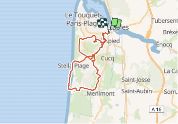
Tocht Mountainbike van 29 km beschikbaar op Hauts-de-France, Pas-de-Calais, Cucq. Deze tocht wordt voorgesteld door domifon.
Plaatsbepaling
Land:
France
Regio :
Hauts-de-France
Departement/Provincie :
Pas-de-Calais
Gemeente :
Cucq
Locatie:
Unknown
Vertrek:(Dec)
Vertrek:(UTM)
402645 ; 5596000 (31U) N.
Opmerkingen