


Pont de Bonne DEPS 10

thomarche
Gebruiker
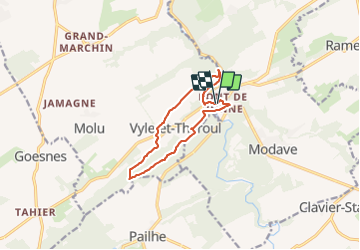

Lengte
9,4 km

Max. hoogte
265 m

Positief hoogteverschil
168 m
Km-Effort
11,6 km

Min. hoogte
167 m

Negatief hoogteverschil
172 m
Boucle
Ja
Datum van aanmaak :
2021-11-14 13:01:01.0
Laatste wijziging :
2021-11-14 15:15:22.165
2h13
Moeilijkheid : Gemakkelijk

Gratisgps-wandelapplicatie
 SityTrail
IGN / Geografische instituten
SityTrail Plus
De wereld gaat voor u open
Over ons
Tocht Stappen van 9,4 km beschikbaar op Wallonië, Luik, Modave. Deze tocht wordt voorgesteld door thomarche.
Plaatsbepaling
Land:
Belgium
Regio :
Wallonië
Departement/Provincie :
Luik
Gemeente :
Modave
Locatie:
Unknown
Vertrek:(Dec)
Vertrek:(UTM)
662048 ; 5591319 (31U) N.
Opmerkingen