


Fourche eu eau croix baguet haut des planches

audrey54
Gebruiker
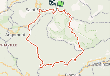

Lengte
21 km

Max. hoogte
668 m

Positief hoogteverschil
577 m
Km-Effort
28 km

Min. hoogte
339 m

Negatief hoogteverschil
577 m
Boucle
Ja
Datum van aanmaak :
2021-11-18 09:03:05.0
Laatste wijziging :
2021-11-18 13:51:22.409
4h25
Moeilijkheid : Zeer moeilijk

Gratisgps-wandelapplicatie
 SityTrail
IGN / Geografische instituten
SityTrail Plus
De wereld gaat voor u open
Over ons
Tocht Stappen van 21 km beschikbaar op Grand Est, Meurthe-et-Moselle, Saint-Sauveur. Deze tocht wordt voorgesteld door audrey54.
Plaatsbepaling
Land:
France
Regio :
Grand Est
Departement/Provincie :
Meurthe-et-Moselle
Gemeente :
Saint-Sauveur
Locatie:
Unknown
Vertrek:(Dec)
Vertrek:(UTM)
351832 ; 5377548 (32U) N.
Opmerkingen