


GraphHopper Track

AnneCecile
Gebruiker
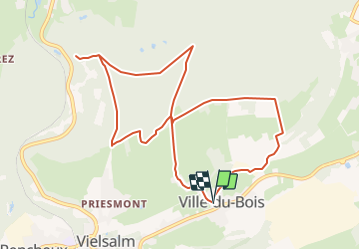

Lengte
9,7 km

Max. hoogte
491 m

Positief hoogteverschil
225 m
Km-Effort
12,7 km

Min. hoogte
371 m

Negatief hoogteverschil
227 m
Boucle
Ja
Datum van aanmaak :
2021-11-25 12:49:52.735
Laatste wijziging :
2021-11-25 13:10:45.588
2h53
Moeilijkheid : Moeilijk

Gratisgps-wandelapplicatie
 SityTrail
IGN / Geografische instituten
SityTrail Plus
De wereld gaat voor u open
Over ons
Tocht Stappen van 9,7 km beschikbaar op Wallonië, Luxemburg, Vielsalm. Deze tocht wordt voorgesteld door AnneCecile.
Beschrijving
Départ : Ville du Bois 77 6690 Vielsalm près de l'église
Plaatsbepaling
Land:
Belgium
Regio :
Wallonië
Departement/Provincie :
Luxemburg
Gemeente :
Vielsalm
Locatie:
Unknown
Vertrek:(Dec)
Vertrek:(UTM)
709085 ; 5575287 (31U) N.
Opmerkingen