


coquin maix par crêtes

Titinechris
Gebruiker
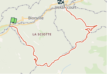

Lengte
19,4 km

Max. hoogte
825 m

Positief hoogteverschil
690 m
Km-Effort
28 km

Min. hoogte
340 m

Negatief hoogteverschil
662 m
Boucle
Neen
Datum van aanmaak :
2021-12-15 08:03:27.318
Laatste wijziging :
2021-12-15 11:45:21.247
3h41
Moeilijkheid : Gemakkelijk

Gratisgps-wandelapplicatie
 SityTrail
IGN / Geografische instituten
SityTrail Plus
De wereld gaat voor u open
Over ons
Tocht Trail van 19,4 km beschikbaar op Grand Est, Vogezen, Celles-sur-Plaine. Deze tocht wordt voorgesteld door Titinechris.
Plaatsbepaling
Land:
France
Regio :
Grand Est
Departement/Provincie :
Vogezen
Gemeente :
Celles-sur-Plaine
Locatie:
Unknown
Vertrek:(Dec)
Vertrek:(UTM)
350810 ; 5371359 (32U) N.
Opmerkingen