


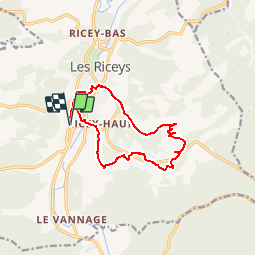
les riceys le replat blanc

pjjrevrard
Gebruiker

Lengte
11,9 km

Max. hoogte
333 m

Positief hoogteverschil
215 m
Km-Effort
14,8 km

Min. hoogte
170 m

Negatief hoogteverschil
215 m
Boucle
Ja
Datum van aanmaak :
2014-12-10 00:00:00.0
Laatste wijziging :
2014-12-10 00:00:00.0
3h18
Moeilijkheid : Gemakkelijk

Gratisgps-wandelapplicatie
 SityTrail
IGN / Geografische instituten
SityTrail Plus
De wereld gaat voor u open
Over ons
Tocht Stappen van 11,9 km beschikbaar op Grand Est, Aube, Les Riceys. Deze tocht wordt voorgesteld door pjjrevrard.
Plaatsbepaling
Land:
France
Regio :
Grand Est
Departement/Provincie :
Aube
Gemeente :
Les Riceys
Locatie:
Unknown
Vertrek:(Dec)
Vertrek:(UTM)
601504 ; 5315492 (31T) N.
Opmerkingen