


pp

CDSM 55
Gebruiker

Lengte
5,1 km

Max. hoogte
407 m

Positief hoogteverschil
108 m
Km-Effort
6,3 km

Min. hoogte
326 m

Negatief hoogteverschil
55 m
Boucle
Neen
Datum van aanmaak :
2022-01-12 14:05:35.146
Laatste wijziging :
2022-01-12 15:40:25.587
48m
Moeilijkheid : Gemakkelijk

Gratisgps-wandelapplicatie
 SityTrail
IGN / Geografische instituten
SityTrail Plus
De wereld gaat voor u open
Over ons
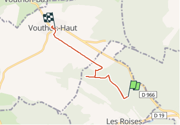
Tocht Mountainbike van 5,1 km beschikbaar op Grand Est, Meuse, Les Roises. Deze tocht wordt voorgesteld door CDSM 55.
Plaatsbepaling
Land:
France
Regio :
Grand Est
Departement/Provincie :
Meuse
Gemeente :
Les Roises
Locatie:
Unknown
Vertrek:(Dec)
Vertrek:(UTM)
695403 ; 5370905 (31U) N.
Opmerkingen