


track

CANON2
Gebruiker
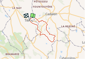

Lengte
10,5 km

Max. hoogte
324 m

Positief hoogteverschil
228 m
Km-Effort
13,5 km

Min. hoogte
208 m

Negatief hoogteverschil
227 m
Boucle
Ja
Datum van aanmaak :
2022-01-18 07:42:25.121
Laatste wijziging :
2022-01-18 07:43:15.685
3h04
Moeilijkheid : Gemakkelijk

Gratisgps-wandelapplicatie
 SityTrail
IGN / Geografische instituten
SityTrail Plus
De wereld gaat voor u open
Over ons
Tocht Te voet van 10,5 km beschikbaar op Occitanië, Tarn, Técou. Deze tocht wordt voorgesteld door CANON2.
Plaatsbepaling
Land:
France
Regio :
Occitanië
Departement/Provincie :
Tarn
Gemeente :
Técou
Locatie:
Unknown
Vertrek:(Dec)
Vertrek:(UTM)
415596 ; 4854947 (31T) N.
Opmerkingen