


hermes 9.8

Djaie60
Gebruiker
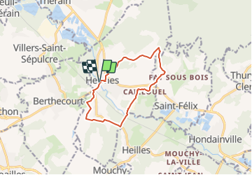

Lengte
9,8 km

Max. hoogte
136 m

Positief hoogteverschil
144 m
Km-Effort
11,7 km

Min. hoogte
42 m

Negatief hoogteverschil
144 m
Boucle
Ja
Datum van aanmaak :
2022-01-24 08:49:35.394
Laatste wijziging :
2022-01-24 08:50:15.545
2h39
Moeilijkheid : Gemakkelijk

Gratisgps-wandelapplicatie
 SityTrail
IGN / Geografische instituten
SityTrail Plus
De wereld gaat voor u open
Over ons
Tocht Te voet van 9,8 km beschikbaar op Hauts-de-France, Oise, Hermes. Deze tocht wordt voorgesteld door Djaie60.
Plaatsbepaling
Land:
France
Regio :
Hauts-de-France
Departement/Provincie :
Oise
Gemeente :
Hermes
Locatie:
Unknown
Vertrek:(Dec)
Vertrek:(UTM)
445179 ; 5467355 (31U) N.
Opmerkingen