


Ercuis 11.7km

Djaie60
Gebruiker
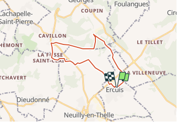

Lengte
11,7 km

Max. hoogte
176 m

Positief hoogteverschil
136 m
Km-Effort
13,5 km

Min. hoogte
101 m

Negatief hoogteverschil
133 m
Boucle
Ja
Datum van aanmaak :
2022-02-07 08:47:51.0
Laatste wijziging :
2022-02-07 08:47:53.404

Gratisgps-wandelapplicatie
 SityTrail
IGN / Geografische instituten
SityTrail Plus
De wereld gaat voor u open
Over ons
Tocht van 11,7 km beschikbaar op Hauts-de-France, Oise, Ercuis. Deze tocht wordt voorgesteld door Djaie60.
Plaatsbepaling
Land:
France
Regio :
Hauts-de-France
Departement/Provincie :
Oise
Gemeente :
Ercuis
Locatie:
Unknown
Vertrek:(Dec)
Vertrek:(UTM)
449478 ; 5454024 (31U) N.
Opmerkingen