


Moutainbikeroute AY39

Commissariat général au Tourisme
Randonnées du CGT GUIDE+
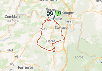

Lengte
20 km

Max. hoogte
386 m

Positief hoogteverschil
481 m
Km-Effort
27 km

Min. hoogte
124 m

Negatief hoogteverschil
480 m
Boucle
Ja
Datum van aanmaak :
2022-02-08 11:21:44.853
Laatste wijziging :
2022-02-21 10:02:49.326
1h50
Moeilijkheid : Medium

Gratisgps-wandelapplicatie
 SityTrail
IGN / Geografische instituten
SityTrail Plus
De wereld gaat voor u open
Over ons
Tocht Mountainbike van 20 km beschikbaar op Wallonië, Luik, Aywaille. Deze tocht wordt voorgesteld door Commissariat général au Tourisme.
Foto's


Plaatsbepaling
Land:
Belgium
Regio :
Wallonië
Departement/Provincie :
Luik
Gemeente :
Aywaille
Locatie:
Unknown
Vertrek:(Dec)
Vertrek:(UTM)
689824 ; 5594710 (31U) N.
Opmerkingen