


Rocher de Bistain

Commissariat général au Tourisme
Randonnées du CGT GUIDE+
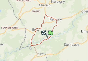

Lengte
9,5 km

Max. hoogte
442 m

Positief hoogteverschil
212 m
Km-Effort
12,3 km

Min. hoogte
371 m

Negatief hoogteverschil
215 m
Boucle
Ja
Datum van aanmaak :
2022-02-08 11:31:22.426
Laatste wijziging :
2022-02-21 10:12:41.844
2h48
Moeilijkheid : Gemakkelijk

Gratisgps-wandelapplicatie
 SityTrail
IGN / Geografische instituten
SityTrail Plus
De wereld gaat voor u open
Over ons
Tocht Te voet van 9,5 km beschikbaar op Wallonië, Luxemburg, Gouvy. Deze tocht wordt voorgesteld door Commissariat général au Tourisme.
Beschrijving
Trail created by Haute Ardenne.
Plaatsbepaling
Land:
Belgium
Regio :
Wallonië
Departement/Provincie :
Luxemburg
Gemeente :
Gouvy
Locatie:
Unknown
Vertrek:(Dec)
Vertrek:(UTM)
704910 ; 5559289 (31U) N.
Opmerkingen