![](/images/other/stat-length.png)
![Tocht Te voet Darscheid - HeimatSpur Pfad der Artenvielfalt - Photo](https://media.geolcdn.com/t/1900/400/ext.pjpeg?maxdim=2&url=https%3A%2F%2Fmedia.geolcdn.com%2Ff%2F46945c2e-932f-4377-b136-a41388844541.jpeg)
HeimatSpur Pfad der Artenvielfalt
SityTrail - itinéraires balisés pédestres
Tous les sentiers balisés d’Europe PRO
![Lengte](/images/other/stat-length.png)
Lengte
10,8 km
![Max. hoogte](https://static1.geolcdn.com/siteimages/upload/files/1508320355ic_sort_altitude_max_24dp.png)
Max. hoogte
544 m
![Positief hoogteverschil](https://static1.geolcdn.com/siteimages/upload/files/1508320355ic_sort_den_pos_24dp.png)
Positief hoogteverschil
198 m
![Km-Effort](/images/other/stat-length.png)
Km-Effort
13,6 km
![Min. hoogte](https://static1.geolcdn.com/siteimages/upload/files/1508320355ic_sort_altitude_min_24dp.png)
Min. hoogte
441 m
![Negatief hoogteverschil](https://static1.geolcdn.com/siteimages/upload/files/1508320355ic_sort_den_neg_24dp.png)
Negatief hoogteverschil
246 m
![Boucle](https://static1.geolcdn.com/siteimages/upload/files/16400158638029165_repeat_loop_refresh_sync_direction_icon.png)
Boucle
Neen
Markering
Datum van aanmaak :
2022-02-11 19:37:19.616
Laatste wijziging :
2022-02-11 19:37:19.616
![Te voet](https://static1.geolcdn.com/sitytour/trail-icons/100.png)
3h05
Moeilijkheid : Gemakkelijk
![Scan deze QR-code om de tocht te openen in de SityTrail-applicatie](https://capi.geolives.com/qq0zvz2zws4bq2lad0pu/sitytour/trails/3100896/qr.png?size=200)
Gratisgps-wandelapplicatie
Over ons
Tocht Te voet van 10,8 km beschikbaar op Rijnland-Palts, Landkreis Vulkaneifel, Darscheid. Deze tocht wordt voorgesteld door SityTrail - itinéraires balisés pédestres.
Beschrijving
Trail created by Natur-Erlebnis-Zentrum Darscheid.
Symbol: Rote Eule
Website: http://www.darscheid.nez-vulkaneifel.de/index.php/projekte/pfad-der-artenvielfalt
Plaatsbepaling
Land:
Germany
Regio :
Rijnland-Palts
Departement/Provincie :
Landkreis Vulkaneifel
Gemeente :
Darscheid
Locatie:
Unknown
Vertrek:(Dec)
Vertrek:(UTM)
350754 ; 5564617 (32U) N.
Opmerkingen
Wandeltochten in de omgeving
![Tocht Te voet Steineberg - HeimatSpur Keltenrundweg - Photo](https://media.geolcdn.com/t/375/260/ext.jpg?maxdim=2&url=https%3A%2F%2Fmedia.geolcdn.com%2Ff%2F4b1692aa-f11b-4d67-8202-607607da5a44.jpeg)
![Te voet Te voet](https://static1.geolcdn.com/sitytour/trail-icons/100.png)
HeimatSpur Keltenrundweg
Te voet
Medium
Steineberg,
Rijnland-Palts,
Landkreis Vulkaneifel,
Germany
![](/images/other/stat-length.png)
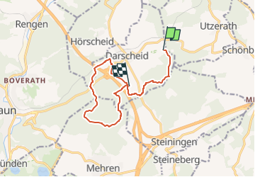
15,4 km | 20 km-effort
4h 36min
![](https://static1.geolcdn.com/siteimages/upload/files/16400158638029165_repeat_loop_refresh_sync_direction_icon.png)
Ja
![Tocht Stappen Schalkenmehren - VulkanEifel Daun - Photo](https://media.geolcdn.com/t/375/260/ext.jpg?maxdim=2&url=https%3A%2F%2Fmedia.geolcdn.com%2Ff%2F24cfb6ee-d49a-4054-9e4b-9172f2529c75.jpg)
![Stappen Stappen](https://static1.geolcdn.com/sitytour/trail-icons/101.png)
VulkanEifel Daun
Stappen
Medium
Schalkenmehren,
Rijnland-Palts,
Landkreis Vulkaneifel,
Germany
![](/images/other/stat-length.png)
3,5 km | 4,7 km-effort
1h 55min
![](https://static1.geolcdn.com/siteimages/upload/files/16400158638029165_repeat_loop_refresh_sync_direction_icon.png)
Ja