


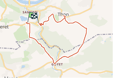
Maizeret Goyet Thon boucle

thomarche
Gebruiker

Lengte
7,7 km

Max. hoogte
204 m

Positief hoogteverschil
163 m
Km-Effort
10 km

Min. hoogte
87 m

Negatief hoogteverschil
209 m
Boucle
Neen
Datum van aanmaak :
2022-02-12 14:51:26.0
Laatste wijziging :
2022-02-12 16:50:55.098
1h59
Moeilijkheid : Heel gemakkelijk

Gratisgps-wandelapplicatie
 SityTrail
IGN / Geografische instituten
SityTrail Plus
De wereld gaat voor u open
Over ons
Tocht Stappen van 7,7 km beschikbaar op Wallonië, Namen, Andenne. Deze tocht wordt voorgesteld door thomarche.
Beschrijving
Belle boucle facile
Plaatsbepaling
Land:
Belgium
Regio :
Wallonië
Departement/Provincie :
Namen
Gemeente :
Andenne
Locatie:
Thon
Vertrek:(Dec)
Vertrek:(UTM)
641532 ; 5591820 (31U) N.
Opmerkingen